
Even though it was 10 p.m., it was still ninety-six degrees. Driving through the grasslands of West Texas, I spent my evening passing by landmarks: the big rare earth mining operation rising out of the horizon with the small sign saying “Desert Minerals,” the Sierra Blanca U.S. Customs and Border Protection (CBP) interior checkpoint, then home. Mexican families starting hours-long night drives heading East on I-10 were securing their truckloads at the gas station.
Sitting next to a fuel pump a clerk smoked her cigarette. An unofficial official—a young guy in spotless sportswear—pulled up to the pump in a tinted black sedan with Texas plates spelling “MDMA CEO.” Familiar rules of safety and power recalibrated under the station’s flickering light.
“Absolutely nuts” is how former U.S. Rep. Will Hurd described what was happening here in Tornillo, Texas in June 2018. He was partly referring to a federal push to increase the number of beds for migrant children at temporary tent facilities by 3,600. An influx of young people categorized by the U.S. government as unaccompanied minors were expected at the border. In less than a year, over 6,000 children would share the experience of being housed in tents near the port of entry, where a bridge over the Rio Grande connects the towns of Tornillo and Guadalupe, Chihuahua.
Hurd’s delirious candor was appropriate, but not for obvious reasons. A former CIA officer who represented a U.S. congressional district spanning the Texas-Mexico border for six years, Hurd might have had political motivations for articulating dismay. The U.S.-Mexico border is a place of conflicting interpretations of the past, present, and future; Hurd accurately illustrated the extremes that emerge from that. Even El Paso’s then mayor, Dee Margo, conceded to the sense of incongruence. While not excellent at explaining responsibilities and orientation, he gave an expert account of what could be called border surrealism: “I don’t know where those children came from, I don’t know where their parents are, we don’t know what’s going on,” he said in June 2018.
Incongruence is a marker of surrealism, and incongruence is one of the first lessons of the U.S.-Mexico borderlands. Penetrate the relational tensions of surveillance, control, legality, and mobility, and it’s clear the border is not two equal “sides.” Spanish and English operate within somewhat ambiguous boundaries. The frontier, or la frontera, might define a categorical line of separation, but it also suggests potential beyond limitation.
A frontier can be a metaphor, but the U.S.-Mexico border is not a metaphor. The migrant housing infrastructure in Tornillo, a word which in English means screw, was rapidly assembled in 2018. Facilities in the town of about 1,600 people were built at high-pitch speed within 24 hours of site selection. I made multiple trips to Tornillo and adjacent towns in El Paso’s Lower Valley that year and continue to visit. It was not a surprise to see politicians, activists, media, artists, and faith leaders quickly arrive in Tornillo and begin to attach credibility to personal projects, further their missions, and see themselves as consequential. The border was remarkably versatile: it could legitimize any agenda that a person chose to connect the space to.
The first shock to institutional plans might have surprised anyone not physically present at Tornillo. What shaped operational momentum wasn’t the complex elements of surveillance, criminal influence, or abstract political and demographic implications. What quickly became the biggest threat to kids detained in Tornillo was a much more basic problem: the heat.
In geographical terms, the U.S.’s southern edge is a line that has been moving for over a hundred years. The Treaty of Guadalupe Hidalgo fixed the river as the boundary in 1848. In Texas and the Mexican states of Chihuahua, Coahuila, Nuevo León, and Tamaulipas, the border obeys water: the Rio Grande.
The Texas borderlands formed in 1882 with the hammering of a silver spike in the Southern Pacific Railroad tracks that spanned the Pecos River at Seminole Canyon. The spike was an inflection point cast in metal that signaled subsequent expropriation, transportation, and speculation. Rail technology connected El Paso to San Antonio and the Gulf Coast.
Today the same canyon at the Pecos feels like the past. The “Mouth of the Pecos” retains hundreds of rock shelters and petroglyphs illustrating shamanistic rituals created by hunter-gatherers 5,000 years ago. In the 1980s, sheep ranchers could still hire hunters to lure roaming pumas into clusters of cyanide pellets.
Villages nearby in Coahuila are partly defined by their recent history of permanent suspension. The La Linda International Bridge, built by Dow Chemical, was once the only border crossing for hundreds of miles. But drug and electronics smuggling, the death of a Mexican customs agent, and local fluorite mines losing their advantages to China prompted it to close in the 1990s.
The dysfunctional bridge and its underwhelming barricade sit between two countries’ massive and extraordinarily undeveloped areas, symbolically designated variously as National Park, Área Natural Protegida, Biosphere Region, or Dark Sky Reserve. It’s about as remote as you can get, one of the darkest places on the continent, and where the frontier becomes otro mundo.
After the novelty of driving to the end of the American road wears off, standing at the midpoint of the unified desert landscape makes the national periphery feel like science fiction. “No drones” is handwritten on a sign at a store where I stop along the way, reminding me I’m at a security-sensitive area, and different rules apply. On the ground, the only material clue that I’ve reached the nation’s limit is a decomposing concrete airstrip and a sunburned metal grill bolted to the bridge.
I see a group of exhausted men sitting beside the road in faded camouflage; the borderlands feel oppressive and unrestrained. I have to quickly calculate moralities and lawfulness and choose one option: do nothing, report them to law enforcement, or offer them water. Giving water, even to those in heat distress, has legal consequences for us all—they’re migrants.

Who’s Running This Town
This frontier is the deepest point in a river, which means that nature plays its role in determining the Texas-Mexico partition and continually redirects its boundary through floods. Washington and Mexico City can play tug-of-war with lines on a map, but the river is unconcerned. The Good Neighbor Policy once kept the two countries committed to keeping their respective waterways flowing as normal. Today though, Mexican farmers are protesting water shipments to the U.S. during a drought, and cartels are moving into the water business—Sinaloa now controls waterways in Chihuahua state. These natural tributaries are themselves tools of power.
Between 1864 and 1873, the river carved a new channel in the Chamizal area of El Paso. The existing treaties stipulated that slow changes, like an accretion of soil or erosion, bring legitimate changes to the boundary. But the velocity of the river’s fluctuation caused a dispute unresolved until 1963, when the U.S. government formally acknowledged that families living in the Chamizal were now living in Mexico and began the transfer of 600 acres of land. After they were given the choice between Mexican and American citizenship, roughly 5,000 people were relocated to other parts of El Paso. On the frontier, nationalities, and boundaries become floating concepts.
“The Guatemalan border with Chiapas is now our southern border,” said Alain Bersin a decade ago. He spoke as the U.S. Commissioner of Customs and Border Protection, informally known as the “Border Czar.” Beginning in 2012, the U.S. Department of Defense began providing as much as $50 million from the Pentagon’s counter-drug budget for patrol boats, night vision equipment, communications, maritime sensors, and training to control the Mexico-Guatemala-Belize border.
Migration patterns were shifting. The majority of people crossing the border used to come from Mexico. That was starting to change as more Central Americans from Guatemala, El Salvador, and Honduras journeyed northward. The Darién Gap is a favored route; it’s a disorienting, roadless jungle between Colombia and Panama that can take weeks to get through. More recently, the source countries are even more far-flung: the number of people from Colombia, Venezuela, Brazil, and Chile—including migrants from the Haitian diasporas the last two countries—and others from across South America traversing it has been growing fast.
Back home in Texas, six hundred miles of plain, desert vistas stretch between Tornillo and Del Rio—the outer limits of national territories. Like me, locals who routinely drive long stretches east-west have time to consider the public imagination of the borderlands. At about the nine-hour mark of staring at the road ahead, the vision of a wall spanning a continent can only feel like folly. It’s no wonder that the bodies of migrants attempting to trek on foot frequently turn up here.
Ambition lives in these deserts too. One morning in July 2021, a small group of us sat on our cars, drank coffee, and fooled around with cameras and phones. It was a social occasion: Blue Origin was launching its first crewed flight. The 11-minute suborbital spaceflight lifted into the sky from Corn Ranch, now called Launch Site One spaceport. It’s a short distance from both the Sierra Blanca CBP interior checkpoint and a desert mountain known as the home of the mechanical “Clock of the Long Now,” built to last 10,000 years as a monument to long-term thinking.
Deep time is a lived experience here: the famous Chihuahuan desert dust covering my car is from long-dead ancient lakes and seabeds. Geologist friends talk about time on a more cavalier scale than even the entrepreneurs pursuing a planetary frontier. But for the migrants, the borderlands are a liminal zone where time is counted by the hour in long-distance drives and high-risk crossings.
“There’s people collapsing out of the heat…they’ve been in the heat day after day after day,” the mayor of Del Rio, Bruno Lozano, reported in 2021. Over the previous year, Del Rio CBP had arrested people from over a hundred different countries. But that fall, the caravan was mainly Haitian families who’d made months-long journeys from Central or South America. An estimated 12,000-15,000 migrants arrived at the international bridge seeking asylum that September.
Meta has pushed for no-cost internet access in Latin America, and caravan organization now happens on WhatsApp groups. It’s a business. WhatsApp is where smugglers are contracted and an array of bad information circulates, from false immigration options to “shelters” that turn migrants along the trail into hostages. The movement of people and digital platforms are increasingly interdependent.
I drove to Del Rio the week after their arrival. I knew a little about what was going on but still couldn’t picture the number of people at the simple bridge. As I looked around, it felt like I’d shown up in a perfectly standard Texas border town: no outstanding infrastructure, a Dollar General at the county line, guys in cowboy hats, single-story whitewashed walls, a small municipal building, and bad drivers from two countries. I asked myself: what was I not seeing?
It turned out that the encampments had already been “cleared.” Over seven days, 15,000 people were suddenly there, and then not there. The dirt at the bridge was flat from bulldozing. The Department of Homeland Security had expelled some families, some returned to Mexico, and some were processed through immigration channels or placed in detainment. People-processing and cleaning up had efficiently obscured 15,000 individual journeys.
In nine days, at least 37 expulsion flights deported 4,000 people with no allowance for asylum requests. The Haitian community and associated charities in Texas helped with personal care, facilitated communication, and chartered buses.
Smooth Movements
“What we want is a crossing that is much faster and more efficient,” said Iván Rivas, Secretary of Economy for Mexico’s northeastern state of Nuevo León, in July. “And maybe there will be a way for other companies in the future as there is for Tesla.”
The only international bridge directly connecting Texas to Nuevo León is the Port of Colombia. That month, the Mexican government granted a customized border crossing to Tesla, as well as to Tesla’s international suppliers from France, Germany, and Taiwan. The companies will have a dedicated fast lane solving a problem that doesn’t exist; current wait times at the regular crossing are usually just five to fifteen minutes. There are plans to maximize the port’s activity and reactivate a railroad.
The Texas-Mexico border is the most active corridor for the movement of people and goods in North America. By 2050, trade value is forecast to grow 234 percent to $1.5 trillion, while the number of individuals crossing northbound is expected to increase 29 percent to 112.4 million people. Tornillo, Del Rio, urban transborder regions like El Paso-Juárez, and the many towns like them are already hybrid cultures—binational communities crossed by a notional boundary. Many here benefit from the border in either its digital or physical form; being porous to capital allows for a high level of mobility. But when it comes to the border as a political reality, this fluidity of goods and people can make things slippery. Mexico’s president, Andres Manuel Lopez Obrador, has opted for increased Army control over security as a way around this—a southern equivalent to the long-standing militarization of the U.S. side.
The judicial border is far more sticky. It travels with me in my pocket and moves constantly according to my phone’s location. CBP is one of several Department of Homeland Security agencies that purchases, through private contractors, massive amounts of location data gathered from hundreds of millions of phones across North America for immigration disciplinary measures, all without a warrant. “There’s a new surveillance blimp by Dryden,” my best friend says over a beer this week. She doesn’t express much care; increased tracking feels expected.
The “datafication” of human and material movement has a flattening effect on interpreting la frontera. If you’re not physically present in the borderlands, data, algorithmic tools, and second-hand cultural translations are your most immediate source of information.
Ideas and idealism about the frontier’s future come from deciphering what’s happening in the present. And, recalling Chamizal, the deported Haitians, or even space tourism, you can discern the speed of change. The paradox that so much activity in a surveilled borderland can be hidden—a cifra negra, a black number, or perhaps a “blind peace”—and so much good, diligent transborder cooperation lacks spectacle, is a reasonable caution against grand theorizing from a distance.
Technological innovation, leadership changes, and reliance on secrecy all introduce aspects of uncertainty as to what the activities and capabilities of powerful actors in both nations are. The interplay between technology and nations should favor the nation with more advanced capabilities. But that logic can be seized and distorted by the narcomundo.
Utopia
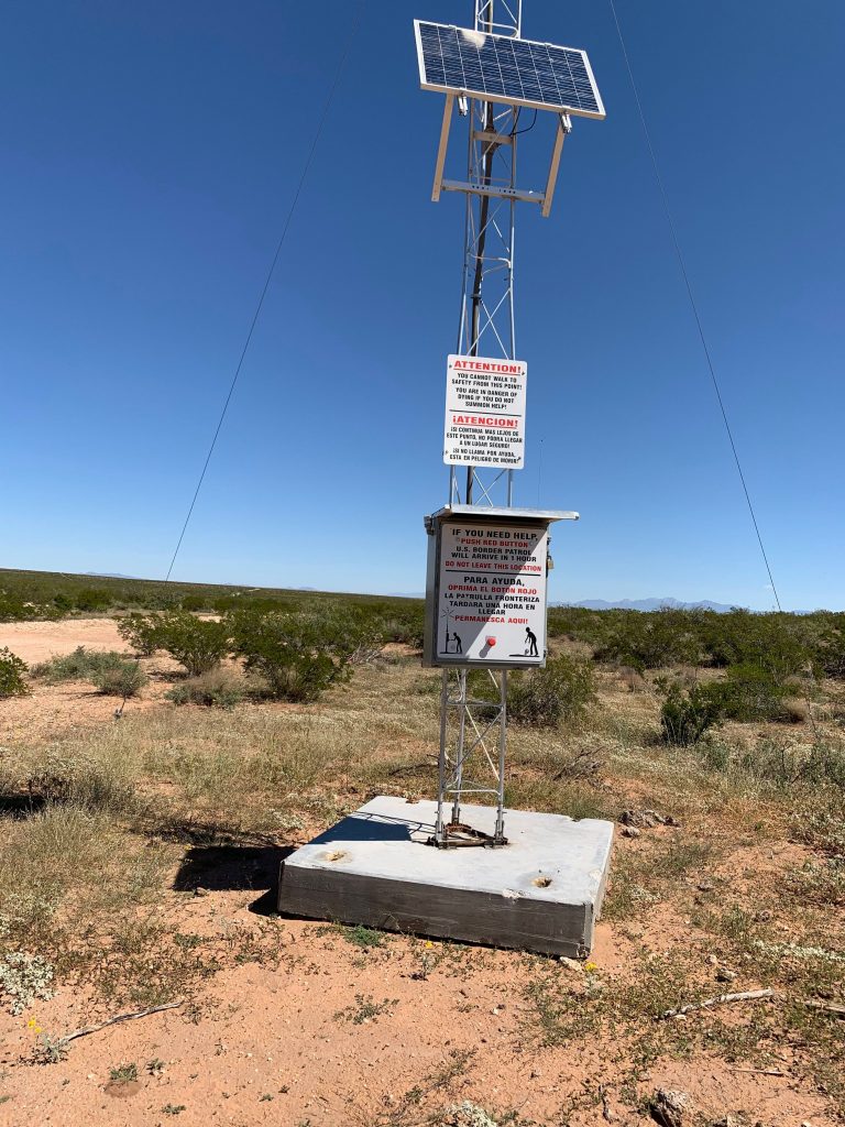
“You are in danger of dying if you do not summon for help! Si continua mas lejos de este punto, no podra llegar a un lugar segura! Push the red button. U.S. Border Patrol will arrive in 1 hour. Permanezca aqui!“
In January 2022 my friend Rick, an archaeologist, started encountering roughly 30-foot-tall CBP desert beacons while exploring the West Potrillo Mountain range in New Mexico. Also called panic poles, the beacons pulse a light that is visible within a ten-mile radius every few seconds. Their warning signs depict a person struggling to stand, depicting what anyone abandoned by their smuggler and walking a long distance in the desert would already feel—disoriented in a hostile landscape.
These mechanical monuments, scattered by an empire in the remote desert, are one piece of an assemblage of new, communications-enabled virtual border imprints. Camera-mounted and designed to be seen, they’re an apparatus that may save your life while also capturing and controlling you. It’s a perfect archetype of border surrealismo: surveillance and humanitarian aid in a single package.
Total surveillance on the border, or the fantasy of such, enables dominance over frontier flows. The expansive, not-always-visible scope of numerous layers of lawful and criminal monitoring systems in the region gives us clues about how things are or aren’t changing.
Returning to Tornillo, and going the short distance across the river to Guadalupe in Mexico, the position of lookouts tells me the temperature of personal risk. The brutality in Guadalupe had been so extreme that there was no police force to speak of for years. The murder of the police chief showed that no one was immune from the consequences of trying to control the space. As a result, the state has de facto yielded its monopoly over the use of violence in this region.
And so, we get mechanical surveillance instead. CBP has embraced the concept of using robot dogs in isolated terrain that is treacherous for vehicles or too vast on foot. Within a few years, human agents might only need to handle non-routine encounters. The robot border patrol dog underlines a militarized, networked landscape and an artificial, technological construction of terra firma. When loaded with sensors, the dogs collect data to accelerate system capabilities and learn more about their human subjects. A scan of media coverage describes the robot dog as futuristic. But in doing so it establishes a baseline future, one we might expect; plenty of the new technological capabilities are not physically shaped like a dog. Some are even invisible.
On a farm divided by empty, hard-packed dirt irrigation channels next to a water treatment plant, a small, gray goat stood in my way. Taking photographs by the fence in May 2021, I was here to see what was going on with water in the Texas colonias—unincorporated towns with decades-long rudimentary water issues. Using my phone which was connected to GPS, I became a digital carrying point in layers of nested monitoring systems. My plates had been scanned at a CBP interior checkpoint too, suddenly making me a small part of big data: satellite networks, RFID, drones, AWS robots, radars, my biometrics, and even C02 detectors all play a role in enforcement infrastructure. This border is a frontier in two senses: at the edge, and cutting-edge.
In a well-known smuggling corridor, it was normal that a network of lookouts was observing me. Amidst auto-repair shops and honey bee farms, a few locals in a raised truck were state-of-the-art threat detection. Meanwhile, on the U.S. side, a dust trail followed a Border Patrol agent in one of their easily recognizable white and green-striped SUVs cruising along a trench. But the state has no monopoly on surveillance, and I was in a live participatory panopticon. Loops of surveillance in the borderlands are an experiment in dominating day-to-day affairs.
Following the river further east, passing the cluster of glimmering four-hundred-year-old Spanish missions and the Ysleta del Sur Pueblo—the region’s oldest running government since its establishment in 1682, and claimant to the longest continually cultivated land in the United States—I drove through green ranchos and tidy pecan orchards. This is where the border wall erected by the U.S. government becomes a strange rhythm of termini: it stops, it starts, it stops, it starts. Although the sense of the state’s ambient intelligence remains, the cracks in the empire’s fortress are blatant and navigable. A wall like this is, functionally, no wall at all.
A violence-as-strategy ecosystem and its presence in daily human affairs is an added departure point into the future. Concerningly, the most violent actors are ramping up their ability to use military-scale tactics. In Michoacan, cartel drones now drop cartel bombs; the use of improvised explosive devices may be a foretaste of things to come. Recently, Texas Governor Greg Abbott joked about using landmines at the border, and on Wednesday issued an executive order designating Mexican drug cartels as terrorist organizations. The same technologies devised to emphasize sovereignty or safety have multi-sided risks.
Borderland Rancheros
“Did you hear about some crypto millionaire that bought that big ranch?” my friend asked. Only after our regular gossip about landowners on a Friday night with neighbors did we talk about the Nine Mile ranch, one of the U.S.’s largest private armed forces training centers. In between getting steaks ready for the barbecue, we got into what’s going on 35 miles from the border at Coahuila. We had no urgent reason to bring it up otherwise; it’s not politically controversial here.
Remoteness is the ranch’s recognizable value when advertising “privacy from prying eyes” to paramilitary groups, security forces, and civilian law-enforcement organizations. Recently adding Spanish to their marketing, a long list of services offered include VIP protection, foreign internal defense, unconventional warfare, desert and urban scenario training, and fuerza letal. A “tent city” at Tornillo is easy to articulate; it describes itself and sounds urgent. A trickier conversation is that 35,000-acre parcel of land, with a runway and exclusive access to another 350,000 acres of private land, can remain largely unseen.
Driving between the tiny towns near the range in February, I was curious enough to pull over at the simple ranch gate marked Nine. I listened to my radio switch between English, Spanish, and dead air. Overhead, a helicopter cruised slowly past a wide, unobstructed horizon. I didn’t expect to see much, but I wondered if I would hear anything.
Publicly available records tell a story of a three-year $5.5 million dollar increase in U.S. Department of Defense contracts awarded to the training range. Most of these support Defense Threat Reduction Agency (DTRA) nuclear, chemical, and bioweapon deterrent programs, including R&D, design for counter-proliferation of weapons of mass destruction, prototype development, and sensor tests.
The desert reliably receded into the distance in a county as big as a European country. My phone lost service. Everything was totally quiet. I took a selfie for no reason but to document myself as part of the scene.
Though only one example in one of the numerous arrangements of the U.S.-Mexico border, the point is that there is a hybrid hierarchy composed of government, corporate, and criminal elements that all influence each other intensely. It’s precisely the frontier—a place most people can’t actually describe beyond their imagination—that will shape the type of safety and conflict we can expect in future decades.
And yet there might be a more basic force determining the momentum of interdependent social rituals and responses to actual human needs.
In the borderlands, “nature” is reliable and readily available as an ally to enforcement strategies—as an ally to violence. The panic pole beacon can be a repellent, persuading people to make bargains on increasingly riskier passages. Turmoil conducted by nature, like the recent drowning deaths of children in El Paso, absolves administrators from moral blame, or even awareness. Cifras negras.
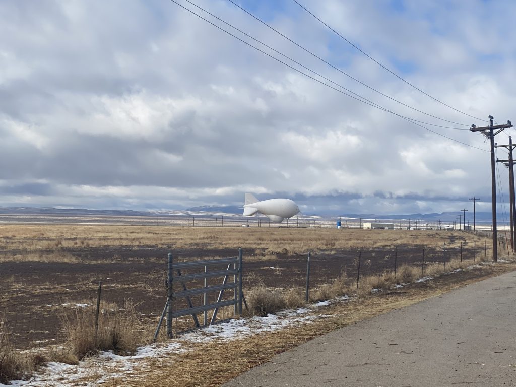
The elemental form of the territorial frontier—water and air alongside dust, sun, and a supernaturally vast horizon, is not incompatible with the proliferation of deterrence technologies. On one of many commutes through Presidio County, Texas, I pulled over to take photographs of the helium-filled TARS blimp. The North American Aerospace Defense Command (NORAD) and U.S. border agencies used the decades-old Tethered Aerostat Radar System for low-level radar surveillance.
The incongruent arrangement of progress, security, and safety was vivid when I got out of my car and felt something hit my face.
It was the heat.